Martinez, California
| City of Martinez | |
|---|---|
| — City — | |
 |
|
 |
|
| Coordinates: | |
| Country | United States |
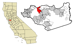
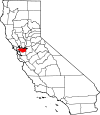
| State | California |
| County | Contra Costa |
| Government | |
| - Mayor | |
| - Senate | Tom Torlakson (D) |
| - Assembly | Mark DeSaulnier (D) |
| - U. S. Congress | George Miller (D) |
| Area | |
| - Total | 13.5 sq mi (34.8 km2) |
| - Land | 12.3 sq mi (31.7 km2) |
| - Water | 1.2 sq mi (3.1 km2) |
| Elevation | 23 ft (7 m) |
| Population (2000) | |
| - Total | 35,866 |
| - Density | 2,656.7/sq mi (1,030.6/km2) |
| Time zone | PST (UTC-8) |
| - Summer (DST) | PDT (UTC-7) |
| ZIP code | 94553 |
| Area code(s) | 925 |
| FIPS code | 06-46114 |
| GNIS feature ID | 0277553 |
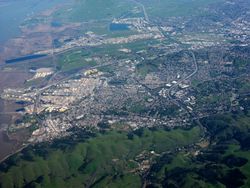
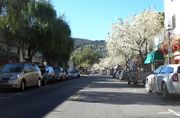
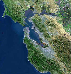
Martinez (pronounced /mɑrˈtiːnɨs/ "mar-TEE-niss" or "mar-TEE-nezz") (from Spanish: Martínez: meaning: Martinson) is a city in and the county seat of Contra Costa County, California, United States.[1] The population was 35,866 at the 2000 census. The downtown is notable for its large number of preserved old buildings. Martinez is located on the south side of the Carquinez Strait in the San Francisco Bay Area, directly facing the city of Benicia.
Contents |
History
In 1824 the Alhambra Valley was included in the Rancho El Pinole Mexican land grant to Ygnacio Martínez.[2] By 1849, Martínez served as a weigh station for the California Gold Rush. The town was laid out in 1849 by Col. William M. Smith and named for Martinez.[3] It became the county seat in 1850, but could not incorporate at the time because it lacked the 200 registered voters required, and only became a city in 1876.[4] In 1847, Dr. Robert Semple contracted to provide ferry service from Martinez to Benicia, CA (across the Carquinez straight, Benicia was a growing community and state capitol for a year in 1852).[2] Martinez was the home of John Muir from 1880 until his death in 1914. He was buried about a mile south of the building that is now the John Muir National Historic Site. Also nearby is the Vicente Martinez Adobe, built in 1849 by the son of Ygnacio Martinez.[4]
The first post office opened in 1851.[3]
In 1860, Martinez played a role in the Pony Express, where riders would take the ferry from Benicia (particularly if they missed the steamer in Sacramento).[5] In 1915, Shell Oil Company built an oil refinery near Martinez, which sparked a building boom in the area. Martinez's oil refineries can still be seen today from Interstate 680, and it continues to be a significant port and petroleum processing center.
Martinez features in a folk etymology regarding the Martini cocktail.[6]
Joltin' Joe DiMaggio was born and raised in Martinez.
Geography
According to the United States Census Bureau, the city has a total area of 13.4 square miles (34.8 km²), of which, 12.2 square miles (31.7 km²) of it is land and 1.2 square miles (3.1 km²) of it (8.92%) is water.
Although the common perception of Martinez is that of a refinery town, given the view from Highway 680 across the Shell refinery and the strong smell of petroleum that greets visitors coming from the Martinez-Benicia Bridge, the city is in fact largely surrounded by water and regional open space preserves. The Martinez-Benicia Bridge carries Highway 680 across the eastern end of the Carquinez Strait to Solano County. The city can be defined as a more densely built downtown valley threaded by Alhambra creek and north of Highway 4. Suburban areas stretch south of Highway 4 to join the neighboring city of Pleasant Hill. Unincorporated areas include the rural Alhambra Valley and the Franklin Canyon area.
The Martinez Regional Shoreline bounds the city to the north along the Carquinez Strait. Carquinez Strait Regional Shoreline includes the Franklin Hills west of downtown, stretching west to the unincorporated community of Port Costa and the town of Crockett. Briones Regional Park borders the Alhambra Valley to the south. Waterbird Regional Preserve and the McNabney Marsh border the city and Highway 680 to the east. Martinez's location at the east end of the Carquinez Strait as it widens to Suisun Bay includes dramatic water views stretching to the Sierra range. From surrounding ridge tops views stretch to nearby Mt. Diablo, Mt. St. Helena, Mt. Tamalpais, etc.
Martinez is one of the only two places in the Bay Area, the other being Golden Gate Bridge, where the Bay Area Ridge Trail and the San Francisco Bay Trail converge. The Bay Trail is a planned recreational corridor that, when complete, will encircle San Francisco and San Pablo bays with a continuous 400-mile (640 km) network of bicycling and hiking trails. It will connect the shoreline of all nine Bay Area counties, link 47 cities, and cross the major toll bridges in the region, including the Martinez-Benicia Bridge. To date, approximately 240 miles (390 km) of the alignment—over half the Bay Trail’s ultimate length—have been completed. The Bay Area Ridge Trail ultimately will be a 500+ mile trail encircling the San Francisco Bay along the ridge tops, open to hikers, equestrians, mountain bicyclists, and outdoor enthusiasts of all types. So far, over 300 miles (480 km) of trail have been dedicated for use. East Bay Regional Park District's Iron Horse Regional Trail will join the Bay Trail along the waterfront, and the Contra Costa Canal Trail threads through the city from Pleasant Hill to the south.
Climate
Martinez has a Mediterranean climate (Köppen climate classification Csa/b).
| Climate data for Martinez | |||||||||||||
|---|---|---|---|---|---|---|---|---|---|---|---|---|---|
| Month | Jan | Feb | Mar | Apr | May | Jun | Jul | Aug | Sep | Oct | Nov | Dec | Year |
| Source: Weather Channel [7] | |||||||||||||
Demographics
.jpg)
As of the census[8] of 2000, there were 35,866 people, 14,300 households, and 9,209 families residing in the city. The population density was 2,927.6 people per square mile (1,130.4/km²). There were 14,597 housing units at an average density of 1,191.5/sq mi (460.1/km²). The racial makeup of the city was 81.03% White, 3.35% Black or African American, 0.74% Native American, 6.63% Asian, 0.23% Pacific Islander, 3.29% from other races, and 4.72% from two or more races. 10.20% of the population were Hispanic or Latino of any race. 11.7% were of German, 10.8% Irish, 10.2% Italian, 9.4% English and 5.4% American ancestry according to Census 2000.
There were 14,300 households out of which 30.0% had children under the age of 18 living with them, 49.4% were married couples living together, 11.0% had a female householder with no husband present, and 35.6% were non-families. 27.4% of all households were made up of individuals and 6.9% had someone living alone who was 65 years of age or older. The average household size was 2.41 and the average family size was 2.96.
In the city the population was spread out with 22.7% under the age of 18, 7.3% from 18 to 24, 32.6% from 25 to 44, 27.3% from 45 to 64, and 10.1% who were 65 years of age or older. The median age was 39 years. For every 100 females there were 98.5 males. For every 100 females age 18 and over, there were 96.0 males.
The median income for a household in the city was $63,010, and the median income for a family was $77,411 (these figures had risen to $73,668 and $92,486 respectively as of a 2007 estimate)[9]. Males had a median income of $52,135 versus $40,714 for females. The per capita income for the city was $29,701. About 3.2% of families and 5.2% of the population were below the poverty line, including 3.9% of those under age 18 and 4.8% of those age 65 or over.
The languages spoken were 88% English, 6% Spanish, 2% Tagalog, 1% German, 1% Chinese, 0.5% Italian, 0.5% Persian, 0.3% Korean, 0.3% Portuguese, 0.25% Russian, 0.25% Arabic, 0.2% Dutch, 0.2% Polish, 0.2% French, 0.2% Punjabi, 0.2%Vietnamese, 0.14% Japanese, 0.14% Tamil, 0.07% Cantonese. Of the 4,176 people who did not use English as their primary language 3,663 (87.72%) spoke it well or very well while 513 (12.28%) spoke it "not well" or "not at all"[10]
Transportation
Rail
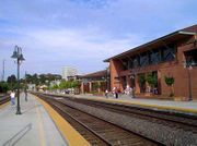
- Amtrak, the national passenger rail system, runs its California Zephyr daily in each direction through Martinez on its route between Emeryville (across the bay from San Francisco) and Chicago, also passing through Sacramento, Reno, Salt Lake City, Denver, and Omaha.
- Amtrak's Coast Starlight operates daily in each direction through Martinez between Seattle and Los Angeles.
- Amtrak California operates its Capitol Corridor trains through Martinez station, providing service several times daily between San Jose to the west and Auburn to the east (via Sacramento).
- Amtrak California also runs its San Joaquin trains through Martinez, providing service several times daily between Oakland to the west and Bakersfield at the south end of the San Joaquin Valley. Bus connections branch off both the San Joaquins and the Capitol Corridor, providing service as far as San Diego; Las Vegas and Sparks, Nevada; and Medford, Oregon. One connection originates in Martinez and runs as far north as the Eureka area.
- BART makes a stop at a station called North Concord/Martinez, although this station lies miles east of the city limits. The city was overlooked when the system was extended from Concord to Bay Point. However BART's long term plans include a new line extension running from Fremont and through the I-680 corridor and ending in Martinez. The new line will run along this course and continue along the planned extension to San José. Another planned configuration will be a BART or BART substitute rail service running between Martinez and East County.
Bus
- WestCAT provides service to El Cerrito del Norte BART Station.
- The County Connection is the primary local bus operator providing service throughout the area. Among its destinations are the Concord, Pleasant Hill, and Walnut Creek BART stations. The County Connection also provides paratransit service.
- The Benicia Breeze crosses the Benicia-Martinez Bridge to Solano County and stops in Benicia and at the Vallejo Ferry Terminal in Vallejo.
- Tri-Delta Transit runs express service between Martinez and eastern Contra Costa County.
Major highways
- State Route 4 runs through Martinez westward to Hercules and eastward through Stockton and the Sierra Nevada to near the border of Nevada.
- Interstate 680 runs northward across the Benicia-Martinez Bridge toward Sacramento via Interstate 80 and southward toward San Jose.
Education
Covering most of Martinez, the Martinez Unified School District encompasses four elementary schools, one middle school, one high school, and two alternative/independent study schools. Students in K-5 attend John Swett, John Muir, Las Juntas, or Morello Park Elementary School. Martinez Junior High School serves students in grades 6 through 8. St. Catherine of Siena is a private Catholic school that serves grades K-8. Alhambra High School serves as the districts' comprehensive high school. As of 2006, the districts' K-12 enrollment was 4,194. Part of Martinez is served by the Mount Diablo Unified School District, whose Hidden Valley Elementary School is located in Martinez. St. Catherine of Siena School (Martinez, California), a private Roman Catholic elementary, also serves the Martinez community.
Public libraries
The Martinez Library of the Contra Costa County Library is located in Martinez.[11]
Beaver controversy
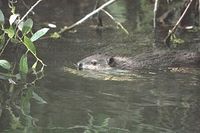
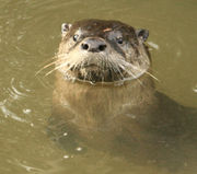
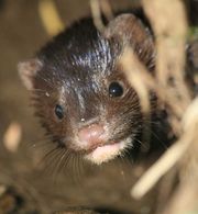

In early 2007, a group of beavers settled in a section of Alhambra Creek that flows through the city.[12] The beavers and their dam became a local attraction. Because the six foot high, 30 foot wide dam created a potential flood hazard, local officials proposed to remove the beavers. Increased run-off from developed areas along the creek has increased flooding in Martinez, a low lying city built on a flood plain, in recent decades. Although Martinez had completed the construction of a $9.7 million dollar flood control project in 1999, the downtown was flooded in 2005, ironically two years before the beavers arrived. A City Council subcommittee was formed to consider whether the beavers could be protected and flood risk managed, and was given 90 days to issue a report to the full council for a vote.[13] During this period, expert Skip Lisle was hired to install a flow device that could reduce the level of impounded water behind the beaver dam and mitigate flooding risk above the beaver dam.[14] The beavers have received national attention, amateur video coverage, a webpage devoted to them, and a new nonprofit organization ("Worth A Dam") formed.[15] The beaver have transformed Alhambra Creek from a trickle into multiple dams and beaver ponds, which in turn, led to the return of steelhead trout (Oncorhynchus mykiss) and river otter (Lontra canadensis) in 2008, and mink (Neovison vison) in 2009.[16][17] The beaver parents have produced babies every year since their 2006 arrival.[18] However, in June, 2010, after birthing and successfully weaning triplets this year (and quadruplets the previous three years), "Mom Beaver" died of natural causes.[19]
The Martinez beavers probably originated from the Sacramento-San Joaquin River Delta. Historically, before the California Fur Rush of the late eighteenth and early nineteenth centuries, the Delta probably held the largest concentration of beaver in North America. It was California's early fur trade, more than any other single factor, that opened up the West, and the San Francisco Bay Area in particular, to world trade. In 1840, explorer Captain Thomas Farnham wrote that "There is probably no spot of equal extent in the whole continent of America which contains so many of these muchsought animals."[20]
See also
- John Muir National Historic Site
- Alhambra Creek
Notable residents
- Yau-Man Chan, Survivor Fiji
- Ella Leffland, author of National Book Award winner The Knight, Death and The Devil, a historical novel based on Nazi Hermann Goering, was born in Martinez in 1931. Her critically acclaimed novel Rumors of Peace is drawn from the author's adolescence in Martinez (called Mendoza) during World War II.
- John Muir, Naturalist
- Tug McGraw, baseball player
- Jello Biafra, Song writer
- Sara Del Rey, Professional Wrestler
- Joe DiMaggio, New York Yankee baseball player, was born in the town in 1914.
- NFL head coach Norv Turner and his brother Ron who is on the Chicago Bears staff grew up in Martinez.
- Jeff Van Gundy, Former Houston Rockets head coach and current ESPN announcer, and his brother Stan Van Gundy, current head coach of the NBA's Orlando Magic, were raised in Martinez.
- Maurice Benard, Actor known for playing Sonny Corinthos on General Hospital.
- Norman Francis McFarland, Roman Catholic bishop
References
- ↑ "Find a County". National Association of Counties. http://www.naco.org/Template.cfm?Section=Find_a_County&Template=/cffiles/counties/usamap.cfm. Retrieved 2008-01-31.
- ↑ 2.0 2.1 Martinez Historical Society
- ↑ 3.0 3.1 Durham, David L. (1998). California's Geographic Names: A Gazetteer of Historic and Modern Names of the State. Quill Driver Books. p. 660. ISBN 9781884995149.
- ↑ 4.0 4.1 Martinez, CA, City History
- ↑ Martinez History and the Pony Express
- ↑ City of Martinez: The History of the Martini
- ↑ Average weather for Martinez Weather Channel Retrieved 2008-03-30
- ↑ "American FactFinder". United States Census Bureau. http://factfinder.census.gov. Retrieved 2008-01-31.
- ↑ Martinez, California US Census Bureau
- ↑ MLA Data Center, Martínez, California entry, U.S. Census Dept. (Census 2000), retrieved 2008-01-17
- ↑ "Martinez Library." Contra Costa County Library. Retrieved on April 1, 2010.
- ↑ Jason B. Johnson (May 21, 2007). "Martinez Beavers set up shop downtown:Mayor says they've become city's most popular attraction". San Francisco Chronicle. http://www.sfgate.com/cgi-bin/article.cgi?f=/c/a/2007/05/21/BAG7RPUHRP1.DTL. Retrieved Nov. 22, 2009.
- ↑ "Martinez Beaver Dam Safe Despite Rough Storms". CBS News. January 4, 2008. http://cbs5.com/local/martinez.beaver.dam.2.623302.html.
- ↑ "Telluride Leaves It to Beaver". United States Golf Association. January/February 2005. http://www.usga.org/turf/green_section_record/2005/jan_feb/Telluride.html.
- ↑ "Martinez Beavers". martinezbeavers.org. http://martinezbeavers.com/wordpress.
- ↑ Aleta George (2008). "Martinez Beavers". Bay Nature Institute. http://baynature.org/articles/jan-mar-2008/ear-to-the-ground/martinez-beavers. Retrieved Nov. 6, 2009.
- ↑ Nicola DeRobertis-Theye. "Beavers and More in Martinez:New Habitat Thanks to Beavers". Bay Nature Institute. http://baynature.org/articles/web-only-articles/beavers-and-more-in-martinez. Retrieved Nov. 6, 2009.
- ↑ Carolyn Jones (2010-06-11). "New baby beaver has Martinez residents beaming". San Francisco Chronicle. http://www.sfgate.com/cgi-bin/article.cgi?f=/c/a/2010/06/10/BA491DSOQP.DTL. Retrieved June 12, 2010.
- ↑ Joe Eaton (2010-07=05). "Wild Neighbors: A Death in the Family". The Berkeley Daily Planet. http://www.berkeleydailyplanet.com/issue/2010-07-06/article/35754?headline=Wild-Neighbors-A-Death-in-the-Family. Retrieved 2010-07-06.
- ↑ Thomas Jefferson Farnham (1857). Life, adventures, and travels in California. Blakeman & Co.. p. 383. http://books.google.com/books?id=cwMNAAAAIAAJ&dq=travels+in+california+farnham&printsec=frontcover&source=bl&ots=SdRWTbf-Pd&sig=MjCsrczlM3u6afZyHz-M1tP7M7s&hl=en&ei=Tez0SsHpIIXuswPf4bQG&sa=X&oi=book_result&ct=result&resnum=1&ved=0CAoQ6AEwAA#v=onepage&q=beaver&f=false.
External links
- City of Martinez homepage
- Martinez Area Chamber of Commerce homepage
- "Worth a Dam": Martinez-based non-profit organization providing beaver education
|
|||||||||||||||||||||||||
|
||||||||||||||||||||
|
|||||||||||
|
|||||||||||||||||||||||
 |
Port Costa | Benicia | |
|
| Hercules | Pacheco | |||
| Pinole Richmond |
Lafayette | Pleasant Hill |